Towns across Australia have been warned of an imminent horrifying wild weather season that will see floods, uncontrollable grassfires and heavy storms hit the country.
Inside their special report on Australia’s weather, Sky News meteorologists Alison Osborne and Rob Sharpe demystified analytical data which gives a gloomy picture of Australia’s harsh weather outlook from this October to April next year.
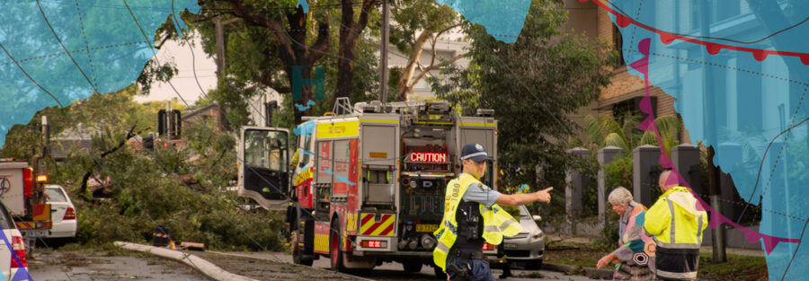
This news comes on the two year anniversary of the destructive Brisbane Halloween hail storm where the largest hail in 30 years was recorded in Springfield Lakes, south west of Brisbane. This storm alone left a trail of destruction to homes and business leaving a damage bill of more than $1.05 billion.
Following this a year later in 2021, again in October, Queensland’s severe storm season started with supercells that saw giant hailstones destroying homes and vehicles as well as two tornadoes touching down near Toowoomba and Gladstone. This particular supercell was reportedly caused from a warm and humid airmass residing over southeastern districts together with strong winds aloft associated with an upper trough” the Bureau of Meterology (BoM) said
Last years extreme weather season experienced in Australia was marred by heavy rains in eastern parts of the country and unprecedented heatwaves along west Australia’s coastal areas although the larger part of the country didn’t experience much of the severe conditions.
This year’s weather is set to be different and crueler.
According to predictions by Sky News Australia, every region in Australia is at a higher risk of recording at least one extreme weather event.
Residents of NSW and Queensland have already received wild thunderstorm alerts from their respective State Emergency Service after some regions received a downpour of more than 300 millimetres in just a few hours.
Eastern Parts of Australia Brace for Wetter Weather
So far, flooding is turning out as the greatest threat to Australia. This comes in the aftermath of catastrophic floods that hit eastern NSW and south-eastern Queensland, with the worst-case scenario being the devastating events in the Northern River in Lismore where some people lost their lives and hundreds of others lost their properties.
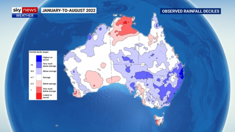
The parts marked with blue have recorded above-average showers in the last eight months with the highest rainfall being received in the regions marked with the darkest blue hue and this includes Sydney and Brisbane.
From the onset of this harsh weather season, soil, dams and rivers were overflowing with water compared to the same period last year.
The rainfall outlook across Australia appears similar and features three main climate drivers—La Niña included, that are triggering wet weather in the eastern parts of Australia.
Consequently, the wet start and the same weather outlook are predictive of more prevalent flooding compared to 2021—with NSW, QLD and VIC having the highest risk.
The Murray Darling Basin will probably witness the worst flooding in 50 years.
The massive basin stretches from the southern interior of Queensland, extending to inland NSW through to northern Victoria and southeast SA.
Dams within this basin are having an average of 96 per cent or full capacity and underfoot are exceptionally wet with substantial and continued flooding along some rivers.
According to our predictions, water flowing through this system might surpass the 2011 and 2016 levels, causing the worst flooding ever recorded since 1974.
The imminent tropical cyclone season in northern Australia could be the most active in the last 17 years. In 2021, ten tropical cyclones were sighted in Australian waters though only two ended in landfall.
During this year, about ten to 13 cyclones are expected to form within the Australian waters. We have estimated that 4 or five cyclones will make a landfill.
A Season of Floods and Fires
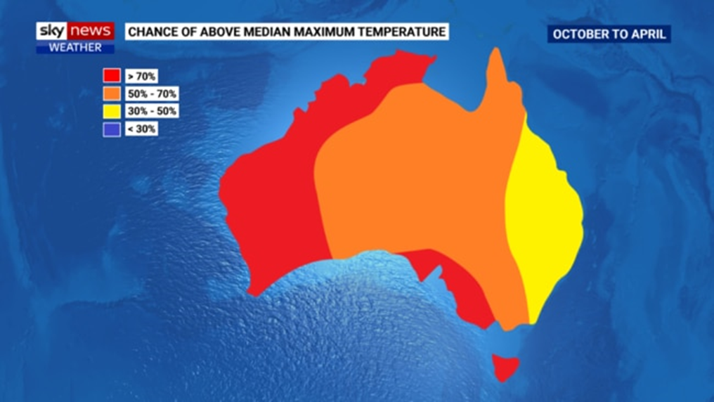
Despite the severe weather events of cyclones and rainfall, most parts of Australia will experience the usual hotness. Heatwaves are forecast in the western parts of Australia and the southern coastal areas.
Central Australia has the highest risk of wild grassfires given the great fuel oodles and the possibility of recording hot weather that dries out a landscape faster when there’s a significant gap in rain activities.
Thankfully, dangerous thunderstorms are considered a lesser threat in parts of eastern Australia owing to the frequency of rainfall and not storms.
However, the central, southern and western parts of Australia are faced with two storm drivers—excess heat and moisture, which are expected to generate more severe thunderstorm events than normal.
As such, almost everywhere in Australia is moving into the months ahead with a given level of increased threat of extreme weather events during the current spell.
Rains, La Nina and Climate
La Nina reoccurred within the Pacific Ocean, though other drivers are also shaping the present weather outline.
The two climate triggers that are considered active and set to play a great role in Australia’s extreme weather pattern and also point to too much rainfall in the eastern parts of Australia
La Nina is the most common.
The La Nina climate influencer is expected to stay active during spring and through to early summer, an indication of excess rains for the residents of eastern Australia.
La Nina was sighted in the Pacific Ocean about a month ago. It’s expected to stay active in spring through to the start of summer.
In contrast to the previous season, this year’s La Nina is expected to have disappeared by March.
In spring, La Nina delivers more rainfall to central, eastern and northern Australia while during summer, its influence shrinks, shifting to half of the eastern parts of the continent, with Queensland bearing its brunt.
Just like it happened last year, a negative Indian Ocean dipole (IOD) event is on the way, though it’s forecast to be more powerful than last year’s.
These events cause more rainfall in central, northern and eastern inland Australia during spring, but have nearly zero influence on summer falls since it usually ends as the seasons transition.
Lastly, the third and least mentioned climate driver will be more active during this harsh weather season.
‘More flooding’ forecast over inland NSW
According to Jane Golding, the Bureau of Meteorology’s Hazard Preparedness Manager, Australia has issued a flood warning over inland New South Wales with changing weather triggering heavy flooding.
The Southern Annular Mode (SAM) is the northern and southern movements of the westerly winds band moving around Antarctica.
When these winds shrink and shift to Antarctica while in their positive phases, they deliver just a few cold fronts within southern Australia and increased easterly winds that bring rainfall to the eastern region of the continent.
Surprisingly, the Tonga underwater volcano which erupted in January firing massive clouds of smoke and water into the air is expected to result in a rather powerful positive SAM throughout the coming spring and summer.
When all these weather drivers are put into consideration during the harsh weather season, then most parts of Australia are set to be wetter than usual, especially in the eastern and northern areas of the country.
The map shown above is a forecast that indicates lightly higher rainfall compared to the same period last year.
During spring, most parts of central, eastern and northern Australia are likely to record wetter than normal weather. But, the strongest drivers during summer will be experienced in the southeast and northeast regions of Australia.
Some parts of the country will experience drier than usual weather and these include southwestern WA and west of Tasmania, thanks to the fewer-than-normal cold fronts forecast.
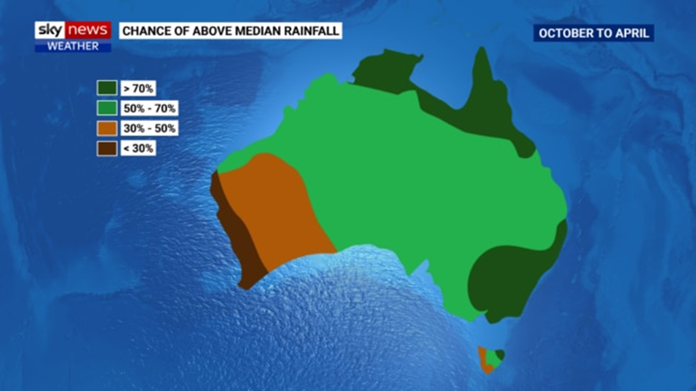
Among the cities, Sydney is expected to record above-average rainfall closely followed by Canberra, Brisbane, Darwin and Melbourne. The remaining capitals are forecast to receive near-normal rains.
Australia to Brace for Seven Stormy Months
Recent years have recorded calmer than usual tropical cyclone spells across Australia, though this year might be different as it’s expected to be horrible and set in early.
The last tropical cyclone spell recorded ten systems that tracked through the Australian waters, with one being lower than the long-standing average.
Amongst the systems, Anika and Tiffany made a landfall, which didn’t get anywhere near the average of four crossings expected along the coastline during this season.
While this may appear as a counter-intuitive occurrence considering the likelihood of severe weather activities triggered by climate change, it’s worthwhile to note that a highly heated atmosphere helps to reduce the possibility of experiencing tropical cyclones.
This is simply because their formation is greatly dependent on the existing temperature variance between a colder atmosphere and a warmer tropical sea.
From 2000, Australia records an average of nine tropical cyclones in contrast to the past norm of eleven.
With that, the country is set to experience a highly active than average weather season. That includes a negative IOD, an active La Nina and warmer-than-usual waters in Australia’s north.
Despite the continuing fall in cyclones, our forecast shows between 10 and thirteen cyclones—the highest number since the 2005/2006 cyclone season.
It’s estimated that we will see 4 or five cyclones that will make landfall this cyclone season.

The map shown above indicates a forecast of about three to 6 tropical cyclones within the Coral Sea, more than the three cyclones recorded last year.
The western and northern regions are forecast to record the same number of cyclones as last year’s, except for more landfalls expected along the Western Australia coastline—the country’s main cyclone hot spot.
The earliest tropical cyclone to develop within our waters will be named Darian and it’s likely to develop anytime from November.
The wet season is expected to record more rainfall and tropical cyclones are set to commence much earlier than usual and in a plethora.
Despite the wet season always starting October 1, the BoM has declared a “rainfall onset” in towns situated in northern Australia following heavy showers that hit the 50mm mark in early September.
Several areas of the tablelands and the northern tropical coast hit the mark within a week.
Other tropical areas take quite longer. But this year, most parts of Queensland and the Northern Territory are expected to hit the 50mm mark earlier than the norm.
The north Australian monsoon refers to the start of heaviest falls during the wet season, thanks to the winds carrying massive moisture from South Asia and the Indian Ocean.
Typically, our monsoon starts in the course of the wet spell, delivering widespread extreme rains to most parts of northern Australia, which are known for tropical cyclones.
Normally, the bursts of the initial monsoon often than not arrive in Darwin on Christmas Day.
But during La Nina activities, the earliest monsoon sets in one or two weeks prior around mid-December.
As such, Darwin has a fairly higher-than-normal chance of experiencing early monsoon, heightening the possibility of having a dull and wet Christmas Day.
Generally, the wet season in northern Australia is forecast to be wetter than average due to the effects of La Nina, especially in Queensland tropical areas.
Aussies have been asked to prepare for the impending threat of flash floods, and those within low-lying regions have been warned of bursting river banks.
In addition to the expected cyclones, you must get your cyclone as well as first aid kit handy and set to go.
No matter where you’re situated in Australia, there’s a higher risk of extreme weather events within the next seven months.
Stay alert and be prepared this storm season
There’s no worse time to make decisions than when you’re going through a catastrophic weather event like Brisbane hail storms and floods—you can’t think straight and the world around you feels like its collapsing. Unfortunately, when Mother Nature hits, not even the strongest metal roofing can withstand the large hail in Brisbane that’s damaging our family homes and communities.
For more information, check out the insurance claim guide by Insurance Claims Group.
references: